
Gunung Anak Krakatau or Mount Baby Cracatoa , commonly known in English, is one of the world’s most scientifically significant active volcanic islands. Rising from the Sunda Strait between Java and Sumatra, it occupies the center of a volcanic system whose history extends far beyond the catastrophic eruption of 1883. Anak Krakatau is, in fact, a relatively young volcanic cone born from the remains of that older Krakatau system.
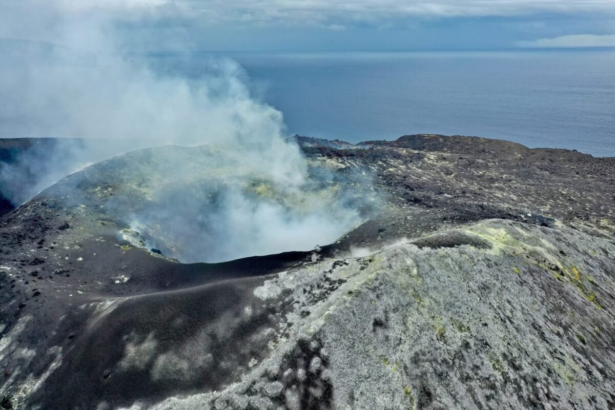
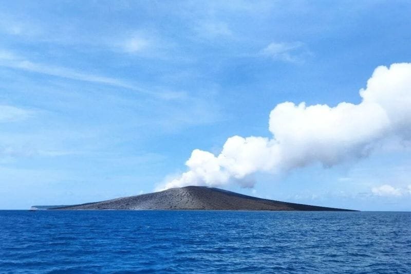
Its importance is not limited to its spectacular eruptions. Anak Krakatau provides scientists with a rare natural laboratory in which geological construction, volcanic activity, island formation, ecological succession, species colonization, and natural hazards can be observed over relatively short periods. The island has repeatedly changed its shape and elevation as lava, ash, scoria, and other volcanic materials accumulate, while explosive activity and landslides can remove large portions of the edifice.
The broader Krakatau volcanic complex is also deeply embedded in Indonesian history and culture. The 1883 eruption became one of the most extensively documented volcanic disasters of the nineteenth century, while the birth and subsequent growth of Anak Krakatau transformed the site into an enduring symbol of geological destruction and renewal.
The modern volcano remains active. Scientific monitoring by Indonesia’s Pusat Vulkanologi dan Mitigasi Bencana Geologi (PVMBG) and international organizations such as the Smithsonian Institution’s Global Volcanism Program has documented continuing eruptive activity. In 2026, for example, reports described renewed explosive and effusive activity, demonstrating that Anak Krakatau is not merely a historical volcano but a dynamic and continuing geological process.
Geographic Setting
Anak Krakatau is located in the Sunda Strait, the marine passage separating Java and Sumatra. Administratively, the volcano is within South Lampung Regency, Lampung Province, although its location places it close to the coastlines of both Lampung and Banten. Indonesia’s Geological Agency identifies Anak Krakatau as an active Type A volcano and maintains observation infrastructure on both sides of the Sunda Strait, including observation posts at Kalianda and Pasauran.
The Smithsonian Global Volcanism Program gives the Krakatau volcanic system coordinates of approximately 6.1009° S and 105.4233° E. Because the volcano is continuously modified by eruptions, lava accumulation, erosion, and collapse, its topographic dimensions should not be regarded as permanently fixed. The Global Volcanism Program currently lists an elevation of about 285 metres, while historical measurements demonstrate how dramatically the height of Anak Krakatau can change through volcanic construction and collapse.
Key Geographic Data
| Parameter | Data | Significance |
|---|---|---|
| Location | Sunda Strait, Indonesia | Separates Java and Sumatra |
| Coordinates | Approx. 6.1009° S, 105.4233° E | Smithsonian GVP reference |
| Volcanic region | Sunda Volcanic Arc | Part of Indonesia’s active volcanic belt |
| Administrative area | South Lampung, Lampung | Indonesian administrative location |
| Current GVP elevation | Approx. 285 m | Elevation changes with eruptions and erosion |
| Volcano type | Caldera, stratovolcano and pyroclastic cone | Reflects complex volcanic history |
| Tectonic setting | Subduction zone | Driven by Indo-Australian plate subduction |
| Major rock types | Basalt, basaltic andesite, andesite, dacite | Indicates evolution of volcanic magma |
| Major historical event | 1883 Krakatau eruption | Catastrophic caldera-forming eruption |
| Anak Krakatau emergence | 1927 onward | New volcanic cone inside 1883 caldera |
The Ancient Krakatau: Before the Birth of Anak Krakatau
To understand Anak Krakatau, it is necessary to understand that the modern island is only one phase in a much older volcanic history.
The Krakatau volcanic system has experienced repeated construction and destruction. Geological evidence indicates that an earlier volcanic edifice underwent a major collapse, producing a caldera approximately 7 kilometres wide. The exact date of this prehistoric event has been debated, with estimates including approximately 416 CE and 535 CE. The Smithsonian Global Volcanism Program generally describes the event as possibly occurring in 416 or 535 CE.
The collapse created a large volcanic depression that subsequently became partly submerged. Three major remnants survived around the caldera: Rakata, Sertung (Verlaten), and Panjang or Rakata Kecil (Lang).
Later volcanic activity produced three major volcanic cones known as:
- Rakata
- Danan
- Perbuwatan
These cones eventually formed a larger volcanic island that became known as Krakatau.
This sequence is important because the Krakatau landscape is not the product of a single eruption. Instead, it represents a long geological cycle:
magma generation → volcanic construction → explosive eruption → structural collapse → marine inundation → renewed volcanic construction.
Anak Krakatau represents the latest major phase of that cycle.
The 1883 Eruption and the Destruction of Krakatau
The 1883 eruption remains the defining event in the modern history of the Krakatau volcanic system.
Activity intensified during 1883, culminating in catastrophic explosions on 26–27 August 1883. The eruption destroyed much of the pre-existing volcanic island and caused a major caldera collapse.
The eruption generated enormous quantities of ash, pumice and other volcanic material. Pyroclastic surges moved across the Sunda Strait, while tsunamis struck coastal areas of Java and Sumatra.
According to the Smithsonian Global Volcanism Program, more than 36,000 people died, with most fatalities attributed to tsunamis rather than direct volcanic products. Pyroclastic surges travelled approximately 40 kilometres across the Sunda Strait and reached the Sumatran coast.
The destruction fundamentally altered the geography of the Sunda Strait.
The former Danan and Perbuwatan cones disappeared, while a remnant of Rakata survived. Much of the previous volcanic edifice collapsed into the sea, producing the caldera that became the geological foundation for the future Anak Krakatau.
The 1883 eruption is also important from the perspective of modern disaster science because it demonstrated that volcanic hazards can interact. The eruption itself was catastrophic, but the resulting tsunami produced an even greater human impact.
Cultural and Historical Significance
The Krakatau disaster became deeply embedded in Indonesian and international historical memory.
Before the 1883 catastrophe, Krakatau was already known to sailors and communities around the Sunda Strait. However, the eruption transformed it from a regional geographical feature into a globally recognized symbol of volcanic power.
The eruption occurred during a period when international telegraph networks and modern newspapers were expanding rapidly. Reports about the eruption therefore travelled much faster than comparable accounts of earlier natural disasters.
The Krakatau event also became part of the scientific development of modern volcanology. Researchers began collecting eyewitness accounts, geological samples, atmospheric observations and measurements of tsunami effects.
Krakatau in Global Culture
The atmospheric consequences of the eruption attracted considerable international attention. Huge amounts of volcanic aerosols and fine particles entered the atmosphere, producing unusual sunsets and other optical phenomena in many parts of the world. The eruption has consequently been associated with nineteenth-century artistic representations of unusual red and orange skies.
The event also influenced literature, journalism and popular perceptions of volcanic catastrophes.
The word Krakatoa, commonly used in English-language literature, is an anglicized form of the Indonesian name Krakatau. Scientific literature today generally uses Krakatau, although Krakatoa remains widespread in English.
Anak Krakatau subsequently acquired a different cultural meaning. Whereas the 1883 Krakatau represented destruction, the “Child of Krakatau” represented rebirth. A new island emerging from the sea in the same volcanic caldera became an extraordinary example of nature reconstructing a landscape destroyed by a previous eruption.
This symbolism—destruction followed by renewal—is one of the most distinctive cultural dimensions of Anak Krakatau.
Birth of Anak Krakatau
Following the 1883 catastrophe, the central part of the Krakatau caldera remained largely submerged.
Then, in December 1927, volcanic activity began to produce a new submarine volcanic feature. By 1928, material had emerged above sea level. This new volcano was named Anak Krakatau, meaning “Child of Krakatau.”
The Smithsonian Global Volcanism Program records that the post-collapse cone was constructed beginning in late 1927 and subsequently became a frequently erupting volcanic center.
The emergence of Anak Krakatau was scientifically remarkable because it could be observed from its earliest stages.
Scientists could study:
- submarine volcanic activity;
- emergence of new land;
- lava accumulation;
- development of volcanic slopes;
- erosion and coastal modification;
- colonization by plants;
- colonization by animals;
- repeated destruction and reconstruction.
In other words, Anak Krakatau became a natural experiment in primary succession on a volcanic island.
Geological Characteristics
Tectonic Setting
Anak Krakatau belongs to the Sunda Volcanic Arc, one of the world’s major volcanic belts.
The volcanic arc exists because the Indo-Australian Plate is being subducted beneath the Eurasian/Sunda plate system. As the oceanic plate descends into the mantle, it contributes to melting processes and generates magma that eventually rises toward the surface.
The Global Volcanism Program classifies Krakatau as being in a subduction-zone tectonic setting with continental crust exceeding approximately 25 kilometres in thickness.
This tectonic setting explains why Indonesia contains so many active volcanoes and why the Sunda Strait is volcanically active.
Magma and Rock Types
The Krakatau volcanic system contains several volcanic rock types, including:
- basalt;
- basaltic andesite;
- andesite;
- dacite;
- minor trachytic and
- trachydacitic compositions.
The presence of different magma compositions demonstrates that the volcanic system is not chemically uniform. Magma can evolve through processes such as fractional crystallization, magma mixing and crustal interaction.
The Global Volcanism Program identifies andesite and basaltic andesite among the major rock types, with dacite and basalt also represented.
Magma composition influences eruption behaviour. More viscous magma can inhibit gas escape, potentially increasing explosive potential, while relatively fluid magma can facilitate lava effusion.
Volcanology of Anak Krakatau
Anak Krakatau is a complex volcanic system exhibiting multiple eruption styles.
Its activity can include:
- Strombolian explosions;
- ash emissions;
- volcanic bombs;
- lava effusion;
- gas-and-steam emissions;
- pyroclastic activity;
- lava fountains;
- flank collapse.
The volcano’s eruption history demonstrates that its behaviour can change over relatively short periods.
The Smithsonian Global Volcanism Program recorded more than 40 eruptive episodes between the beginning of its post-1927 construction and the catastrophic collapse in 2018.
The 2018 Eruption and Tsunami
The most important modern event in Anak Krakatau’s history occurred on 22 December 2018.
Before the disaster, Anak Krakatau had experienced sustained eruptive activity beginning in June 2018. Lava extrusion and explosive activity progressively modified the volcanic edifice.
At approximately 20:55–20:57 local time on 22 December, a major sector of the volcano collapsed laterally into the sea.
The collapse generated a tsunami that struck coastal areas of Java and Sumatra.
Scientific modelling and observational studies indicate tsunami run-up heights of up to approximately 13 metres at some locations. At least 437 people died in the disaster.
The event was particularly significant because it demonstrated that an eruption does not need to be exceptionally explosive to generate a deadly tsunami.
A volcanic flank collapse can displace seawater rapidly, producing a tsunami even when conventional earthquake-based tsunami warning systems may not provide adequate advance warning.
The 2018 Event in Perspective
| Feature | 1883 Event | 2018 Event |
|---|---|---|
| Main process | Massive explosive eruption and caldera collapse | Volcanic flank collapse during eruption |
| Volcano | Pre-1883 Krakatau system | Anak Krakatau |
| Main tsunami mechanism | Large volcanic collapse and eruption-related processes | Rapid lateral flank collapse |
| Human deaths | More than 36,000 | At least 437 |
| Major affected regions | Java and Sumatra | Java and Sumatra |
| Scientific significance | Demonstrated catastrophic volcanic-tsunami interaction | Demonstrated modern risk of non-seismic volcanic tsunami |
The 2018 event also changed the physical morphology of Anak Krakatau. A large portion of the pre-collapse cone disappeared, while a new crater and coastal configuration developed.
Geophysics: How Scientists Monitor Anak Krakatau
Volcanic activity is not monitored solely by visually observing eruptions.
Modern volcanology combines several geophysical techniques.
Seismic Monitoring
Earthquakes beneath volcanoes are among the most important indicators of changing volcanic conditions.
As magma moves through cracks and conduits, it can generate seismic signals. Scientists distinguish different types of volcanic earthquakes, including:
- volcanic-tectonic earthquakes;
- shallow volcanic earthquakes;
- low-frequency events;
- hybrid or multiphase events;
- tremor.
Changes in earthquake frequency, depth and character may indicate changes in magma or gas movement.
PVMBG monitoring has repeatedly documented variations in shallow seismic activity at Anak Krakatau. During an increase in activity in June 2026, for example, monitoring detected increasing signals associated with gas-and-steam emissions, hybrid/multiphase events and low-frequency events.
Ground Deformation
Magma entering or accumulating beneath a volcano can deform the surface.
Scientists therefore monitor:
- inflation;
- deflation;
- horizontal movement;
- vertical movement;
- changes in crater geometry.
Modern satellite radar techniques such as InSAR (Interferometric Synthetic Aperture Radar) are particularly useful for detecting small changes in volcanic surfaces.
Ground-based GPS and other geodetic instruments can complement satellite observations.
Remote Sensing
Because Anak Krakatau is an isolated volcanic island, satellite observation is especially valuable.
Satellites can detect:
- thermal anomalies;
- lava flows;
- ash plumes;
- changes in crater morphology;
- vegetation destruction;
- coastal changes.
Satellite observations have been used to detect thermal anomalies and volcanic emissions around Anak Krakatau.
Infrared imagery can reveal hot lava even when conventional visible-light images are obscured by darkness or clouds.
Gas Monitoring
Volcanic gases provide another indication of magmatic activity.
Important gases include:
- water vapour;
- carbon dioxide;
- sulfur dioxide;
- hydrogen sulfide.
An increase in sulfur dioxide emissions can indicate that magma is approaching shallow levels.
In June 2026, satellite observations detected sulfur dioxide emissions from Krakatau, accompanied by thermal anomalies and increasing shallow seismic signals.
Current Volcanic Behaviour
Anak Krakatau remains an active volcano and should not be considered dormant.
Recent monitoring reports demonstrate that activity can fluctuate substantially. In July 2026, PVMBG reported ash plumes reaching hundreds of metres above the summit during eruptive activity.
In August 2026, activity continued, with variable white-to-gray plumes and restrictions on access to the summit area.
The precise dimensions of the volcano are therefore inherently dynamic. A height recorded during one survey may become obsolete after a significant eruption or collapse.
This is a crucial point when discussing Anak Krakatau: it is better understood as a changing volcanic system than as a fixed mountain.
Biology: Anak Krakatau as a Natural Laboratory
Perhaps one of the most scientifically fascinating aspects of Krakatau is biological succession.
The 1883 eruption effectively devastated the terrestrial ecosystems of the surviving islands. Scientists subsequently had the rare opportunity to observe how plants and animals recolonized volcanic landscapes.
The Krakatau islands therefore became one of the world’s classic examples of studying island biogeography and ecological succession.
Primary Succession
Primary succession occurs when organisms colonize a surface that has little or no pre-existing biological community or developed soil.
New volcanic surfaces initially consist largely of:
- lava;
- ash;
- pumice;
- volcanic sand;
- unstable sediment.
The first organisms must tolerate severe conditions.
They may include:
- algae;
- lichens;
- grasses;
- pioneer herbs;
- ferns;
- coastal plants.
As organic matter accumulates and weathering progresses, soil formation becomes increasingly possible.
Plant Colonization
Research on the Krakatau islands has documented the gradual development of vegetation after the 1883 destruction.
A major ecological study published in Ecological Monographs examined plant recolonization and vegetation succession across the islands. Researchers found that coastal plant communities established relatively early, while interior forests developed progressively and were strongly influenced by volcanic disturbance.
Species found during the succession included various pioneer and forest plants such as:
- Casuarina equisetifolia;
- Ipomoea pes-caprae;
- Ficus species;
- Timonius compressicaulis;
- Dysoxylum gaudichaudianum;
- ferns and other pioneer plants.
The precise plant community varies according to substrate, elevation, moisture, disturbance and proximity to seed sources.
Why Anak Krakatau Is Different from the Older Islands
Anak Krakatau differs significantly from Rakata, Sertung and Panjang because it has remained volcanically active while vegetation was attempting to establish itself.
This creates an unusual ecological situation.
A forest that begins developing can subsequently be damaged or eliminated by:
- ashfall;
- lava flows;
- pyroclastic deposits;
- volcanic bombs;
- heat;
- erosion;
- landslides.
Ecological research has shown that volcanic activity repeatedly interrupted vegetation succession on Anak Krakatau. Earlier studies found that volcanic activity could even eliminate much of the island’s flora and force ecological succession to restart.
This means that Anak Krakatau is not simply progressing from barren land toward mature tropical forest in a linear sequence.
Instead, the ecosystem follows a pattern resembling:
colonization → vegetation development → volcanic disturbance → partial or complete destruction → recolonization → renewed succession.
This cycle is one of the island’s most important biological characteristics.
Animal Colonization
Plants are not the only organisms to colonize volcanic islands.
Animals can reach the islands by:
- flying;
- swimming;
- rafting on vegetation;
- being transported by wind;
- dispersal of seeds through animal activity;
- accidental human transport.
Birds are particularly important because they can travel long distances between islands.
Birds can also accelerate plant succession by transporting seeds in their digestive systems or on their bodies.
Research on Krakatau has shown that animal-dispersed plants became increasingly important as vegetation developed.
Thus, biological colonization is not a collection of independent events. It is a network of ecological interactions.
For example:
birds arrive → birds transport seeds → trees establish → insects and other organisms exploit vegetation → food webs develop → ecological complexity increases.
Marine Biology Around Anak Krakatau
The biological significance of Anak Krakatau extends beneath the sea.
The island is surrounded by marine environments that are influenced by:
- volcanic sediment;
- changing coastlines;
- submarine volcanic deposits;
- coral communities;
- currents;
- water temperature;
- nutrient availability.
Marine ecosystems may also be disturbed by volcanic eruptions and sediment deposition.
At the same time, volcanic islands can create new rocky substrates that eventually become colonized by marine organisms.
The Sunda Strait itself is an ecologically important marine corridor connecting the Java Sea and the Indian Ocean region.
Thus, Anak Krakatau should not be studied only as a terrestrial island. It is part of a coupled volcanic–marine ecosystem.
Geological and Biological Succession Are Interconnected
One of the most interesting lessons from Anak Krakatau is that geology and biology cannot be separated.
A volcanic eruption changes:
- elevation;
- soil;
- coastline;
- drainage;
- temperature;
- substrate chemistry;
- habitat availability.
Those physical changes determine which organisms can survive.
Conversely, vegetation changes the physical environment.
Plants:
- stabilize volcanic ash;
- produce organic matter;
- accelerate soil development;
- reduce erosion;
- provide habitats;
- create shade and moisture;
- facilitate colonization by other species.
Consequently, the landscape gradually evolves from a predominantly geological system into a biological system.
This makes Anak Krakatau an extraordinary natural laboratory for studying the interaction between geology, geomorphology and ecology.
Natural Hazards Associated with Anak Krakatau
Anak Krakatau represents several different types of hazards.
Explosive Eruptions
Explosive eruptions can produce ash, bombs, lapilli and pyroclastic material.
Volcanic ash can affect:
- aviation;
- human health;
- agriculture;
- water supplies;
- machinery.
- 16.2 Lava Flows
Lava flows can destroy vegetation and alter the island’s coastline.
Because the volcano is an island, lava entering the sea can also produce steam and unstable coastal formations.
Pyroclastic Flows and Surges
These are among the most dangerous volcanic phenomena.
They can move rapidly and contain hot mixtures of gas, ash and fragmented volcanic material.
The 1883 eruption demonstrated that pyroclastic surges can travel significant distances over water.
Landslides and Flank Collapse
The 2018 event highlighted one of the most important hazards associated with Anak Krakatau.
Rapid collapse of a volcanic flank into the ocean can generate a tsunami without requiring a large tectonic earthquake.
This is particularly dangerous because conventional earthquake-based tsunami warning mechanisms may not provide sufficient warning.
Tsunami
The volcanic history of Krakatau demonstrates that tsunami hazard must be considered an integral component of volcanic hazard assessment.
The 1883 eruption and 2018 flank collapse both produced devastating tsunamis.
The Importance of Continuous Monitoring
The combination of volcanic activity and nearby coastal populations makes continuous scientific monitoring essential.
PVMBG uses multiple sources of information, including:
- seismic data;
- visual observation;
- gas emissions;
- satellite imagery;
- thermal monitoring;
- geological surveys;
- deformation measurements.
International organizations also contribute data and scientific analysis.
A volcano’s alert level is not simply a prediction that an eruption will occur. Rather, it communicates the observed state of volcanic activity and the associated hazard assessment.
For this reason, visitors, fishermen, vessels and coastal communities should always follow official exclusion zones and warnings issued by Indonesian authorities.
Anak Krakatau and Climate Research
The broader Krakatau eruption of 1883 also has importance for atmospheric science.
Large explosive eruptions can inject sulfur-bearing gases and aerosols into the stratosphere. These particles can influence atmospheric radiation and produce temporary global climatic effects.
The 1883 eruption produced spectacular atmospheric phenomena observed in many regions of the world. Historical evidence includes unusually vivid sunsets and other optical effects.
However, it is important to distinguish the 1883 event from ordinary Anak Krakatau eruptions.
Not every eruption of Anak Krakatau produces a globally significant atmospheric impact. The climatic consequences depend on eruption magnitude, duration, plume height and the amount of sulfur-bearing material injected into the atmosphere.
Scientific Importance of Anak Krakatau
Anak Krakatau is valuable to science because relatively few places allow researchers to observe volcanic construction and ecological succession simultaneously.
Its importance can be summarized in several areas.
Volcanology
Scientists can observe how a new volcanic cone grows and changes.
Geophysics
The volcano provides data about seismicity, deformation, gas movement and thermal processes.
Geology
The volcanic deposits provide evidence of magma evolution, explosive activity and caldera development.
Geomorphology
Researchers can observe rapid erosion, coastal change, landslides and island growth.
Ecology
Scientists can observe how organisms colonize newly created volcanic terrain.
Biogeography
The islands provide a natural experiment in species dispersal and island colonization.
Disaster Science
The 2018 event provided an important case study of tsunami generation by volcanic flank collapse.
A Continuing Natural Experiment
Perhaps the most appropriate way to understand Anak Krakatau is as a continuing natural experiment.
Unlike an ancient geological formation whose development occurred millions of years ago, Anak Krakatau is young enough that many processes remain observable on human timescales.
A single human lifetime can encompass major changes in:
- volcanic morphology;
- vegetation;
- coastline;
- crater structure;
- lava deposits;
- species composition.
This makes Anak Krakatau exceptionally valuable for interdisciplinary research.
The island also demonstrates that geological time is not always slow.
- A mountain can grow substantially within years or decades.
- A volcanic flank can collapse within minutes.
- A tsunami can cross a coastal area within a short period.
- A barren volcanic surface can gradually acquire vegetation.
In this sense, Anak Krakatau compresses several fundamental Earth processes into a relatively accessible natural laboratory.
Conclusion
Mount Anak Krakatau is far more than a famous volcanic island in the Sunda Strait. It is the latest expression of a volcanic system with a history extending through prehistoric eruptions, the construction and destruction of Krakatau, the catastrophic eruption of 1883, the emergence of a new volcanic cone in 1927, and the dramatic flank collapse and tsunami of 2018.
Geographically, its position between Java and Sumatra gives it exceptional strategic and environmental significance. Geologically, it belongs to the highly active Sunda Volcanic Arc, where subduction generates magma and sustains extensive volcanic activity. Volcanologically, it demonstrates a wide range of eruptive processes, including explosive activity, lava extrusion and unstable flank development.
From a geophysical perspective, Anak Krakatau illustrates why volcanic monitoring must integrate seismicity, ground deformation, gas emissions, thermal anomalies and satellite observations. Recent activity confirms that the volcano remains dynamic and requires continuous monitoring.
Biologically, the Krakatau islands have become one of the world’s most important examples of ecological succession. Plants and animals have repeatedly colonized volcanic terrain, while eruptions periodically reset the ecological clock. Research has demonstrated that dispersal, habitat development and volcanic disturbance interact to shape the developing ecosystem.
Historically and culturally, Krakatau represents both catastrophe and renewal. The 1883 eruption became one of the defining natural disasters of the nineteenth century, while the emergence of Anak Krakatau transformed the same site into an extraordinary example of geological rebirth.
The most important scientific lesson may therefore be that Anak Krakatau is not a static mountain. It is a constantly evolving interaction between magma, ocean, atmosphere, geology and life.
Its future cannot be described simply as a prediction of whether another large eruption will occur. Instead, the island should be understood as a continuing geological process. New eruptions may add land; erosion may remove it; vegetation may colonize new surfaces; volcanic activity may destroy established ecosystems; and structural instability may create tsunamis.
For Indonesia and for the international scientific community, Anak Krakatau consequently serves two roles simultaneously: a natural laboratory for understanding the Earth and a reminder of the serious hazards created when volcanism interacts with densely populated coastal environments.
As recent monitoring demonstrates, the volcanic system remains active. Scientific observation, hazard communication, exclusion zones and public preparedness therefore remain essential components of living with Anak Krakatau.
Selected Scientific References
- Smithsonian Institution, Global Volcanism Program — Krakatau Volcano Profile and Activity Reports.
- Pusat Vulkanologi dan Mitigasi Bencana Geologi (PVMBG), Geological Agency of Indonesia — reports concerning Anak Krakatau and its hazards.
- Whittaker, R. J., Bush, M. B., & Richards, K. — Plant Recolonization and Vegetation Succession on the Krakatau Islands, Indonesia, Ecological Monographs.
- Whittaker, R. J. et al. — research on ecological aspects of plant colonization on the Krakatau Islands.
- Scientific Reports — modelling of the tsunami generated by the December 2018 lateral collapse of Anak Krakatau.
- Smithsonian Global Volcanism Program — historical reconstruction of the 1883 eruption and development of Anak Krakatau.